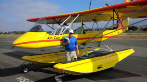
Here’s a quick report on a most memorable flight from Winter Haven, Florida, to my home base at the Arlington, Washington Airport (KAWO).
First, a thank you to the AirCam team at the factory in Sebring who readied N333AE with the new Clamar carbon-fiber amphibious floats and sorted out other issues. From the front office to the mechanics in the hangar, everyone was a pleasure to do business with.
Next, I want to thank the Winter Haven crew who got me certified and on my way home. Richard Johnson, my primary instructor, and John Collins in the Twin Comanche were both superb instructors, professional, and patient.
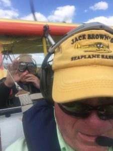
 With the ink barely dry on my multi-engine land and sea certificate, I headed east to Melbourne, Florida, to invite my dad, Commander Grabe Harman USN Ret., for a flight. My dad is a 92-year-old naval aviator seaplane pilot who flew PBYs and PBMs in the Caribbean and South Pacific during World War II. Prior to deployment, he was an instructor pilot at Banana River Naval Air Station, now Patrick Air Force Base. With prior permission, I was able to fly dad down the east side of the river, the same approach he had made many times to land and taxi up to the seaplane ramps. We then circled our old homestead on the Indian River in Cocoa, and did a couple of water landings in Lake Washington just west of Melbourne. By the end of the hour-long flight, dad was grinning from ear to ear and told me I’d done a pretty decent job of the near glassy water landings and takeoffs. Once an instructor pilot (IP), always an IP, I guess.
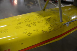
Before leaving Melbourne International Airport (KMLB) the next day, I flew a lineman who had been especially helpful in assisting my dad the previous day and who was really excited about the AirCam. Upon returning from several water landings on the lake and St. Johns River, he was grinning widely. I handed him a Sharpie and, after my dad, he was the second of five folks I flew along the journey to sign the tail of 333AE.
The next day I flew north to Jacksonville to visit long-time friends and, of course, I followed the shoreline at 250 feet in dazzling Florida weather, getting lots of waves from the many beachgoers. I counted many manatees lounging along the way, but I also spotted a small shark lurking among the swimmers at Daytona Beach.
The journey west was aided by tailwinds generated by a couple of offshore early season hurricanes that eventually headed northeast and out to sea. I planned two or three 3-hour legs each day, taking Richard Johnson’s advice to head in the general direction, fly for 2.5 hours or so, touch “nearest” on the GPS and land for fuel/rest/food at a suitable airport. Despite my desire to exercise the floats, I soon found that fuel on the water was a scarce commodity, hence, the amphibious part of the plane was a necessity.
I also carried a 5-gallon can of auto fuel in each float, which came in handy a little later in the journey.
It was over southern Alabama that I discovered an error in flight planning. At 300 feet AGL and with no autopilot, it would have been a very messy situation to refill the water bottle I’d saved for a specific purpose. In serious need of relief, I spotted a beautiful lake. The gear was up, the area clear, so I dropped in for a short relief visit. Tending to business with Mr. AirCam slowly idling to the upwind shore, I looked up to discover I’d landed in the middle of a church camp. Sheepishly I back-taxied to the less inhabited downwind shore to finish business.
I actually made it to Oklahoma City by the second night, again assisted by a merciful tailwind. I’d pay for that advantage in the West a couple of days later. I flew my uncle, Mark Landoll, an EAAer and long-time homebuilder, from his grass strip just outside of the city. Unfamiliar with AirCam’s performance, he was rightly concerned about density altitude and ops from his 2,000-foot grass runway. I showed him the weight and balance numbers then bet him I’d be at 300 feet AGL before I passed his hangar a third of the way down the strip. After that demo, at age 82, he eagerly climbed aboard and off we went. He also got the opportunity to sign the tail, another AirCam enthusiast generated!
Leaving Oklahoma City the next day, the weather gods sent thunderstorms and held me up short of Pueblo, Colorado. The next morning, the tailwinds disappeared, and I made an extra fuel stop to top off prior to heading to Leadville, Colorado.
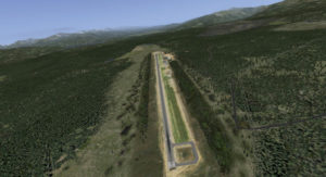
 At 9,937 MSL, Lake County Airport (KLXV) in Leadville is the highest public use airport on the North American continent. I should have landed and taken off with one engine shut down, but I opted not to with an August density altitude pushing 11,500 feet. My takeoff and departure to the north through the Tennessee Pass (10,424 MSL), past Copper Mountain, then the northern route past Eagle County Airport (EGE) to Grand Junction had me mushing along at 12,500 feet or so. I skirted the only storm encountered on the entire trip that dropped a bit of rain, landed, topped off my fuel, and headed to Moab, Utah.
If you check out the various YouTube discussions about the AirCam, you will eventually come across one made for National Geographic. In it, Phil (Lockwood) describes the best AirCam flying in the U.S. Flying in, around, and out of Moab I found out why that statement was true. It is simply amazing countryside. Using the AirCam to its fullest potential, I flew low and slow through the myriad of canyons and routes leading to and from Canyon Lands and Arches national parks. My Go-Pro camera was in near constant use. I couldn’t decide which XM radio channel was best to enhance the pure joy and exhilaration of the flying. I’ve never had such an amazing aerial experience. Ever.
That said, I learned an important—no, make that vital—lesson on this flight. Following a meandering river in the glorious evening sunlight through a lush green valley surrounded by rusty brown canyon walls and mesas, I rounded a bend to come upon a boat launch and a bunch of folks waving—all of us having an absolutely great time. Then, I passed over a wire, safely, but the lesson was suddenly hammered home. Distracted by the glory of the flight, I hadn’t seen the wire prior to flying over it. Although it was a skinny wire, had I been 30 feet lower this story could certainly have had a slightly different ending. ’Nuff said.
Off to Tonopah, Nevada, through Area 51 the next day, the Air Force controllers were okay with my 500-foot AGL progress up and over the hills against a 15- to 20-knot headwind that was not fun. Flight planning this day required flying as far west as Panaca, Nevada, and landing to top off with those 5-gallon gerry cans in each float. Pressing on to Tonopah (KTPH), I elected to stop early, giving up on the headwind and staying at the Historic Mizpah Grand Hotel that was recently renovated.
Next morning I flew to California via Mono Lake and Tioga Pass, flyable at 11,500 feet or so MSL. I planned to use the gerry cans at Lee Vining just before the pass but opted to press on because I was already at the requisite pass altitude. A bit of a headwind caused some fuel angst, but after the pass I’d be flying over the long and narrow Retch Hetchy Reservoir, providing plenty of opportunity to land and empty my gas cans, if needed. As it turned out, I landed at Pine Mountain Lake (E45) after 3.2 hours on the clock and 7 gallons remaining in the tanks.
 Then, I was on to Petaluma, California, in the wine country to visit my daughter and our two new grandchildren. I returned to the airport the next day to find a note taped to the panel from a fellow “ready to buy or build” an AirCam. Could we talk? I took the gent flying, landing in the Petaluma River for a couple of splashes. He’s the No. 4 signer of the tail.
On my final leg(s) to Arlington I intended to fly the coast all the way northward, but coastal fog changed that plan. Instead I flew inland through the giant redwood forests, spending the night in Garberville, California, at another Historic Registry hotel, the Benbow Inn. It’s a great spot with lots of history.
The last day of my flight home was again a long one, with stops at Medford and Newport, Oregon, Olympia, Washington, and finally home to KAWO.
My Flight By The Numbers:
- 14 – days, with two nights in Oklahoma City and 4 in Petaluma (8 days of flying).
- 59.5 – hours on the Hobbs Meter.
- 3.6 to 3.9 gph — average per engine, depending on altitude and rpm, running 4300 to 4900 rpm, with short periods above 5,000 feet (5,200 in the passes at Leadville andTioga/Yosemite).
- 1 – liter of oil consumed between the two engines (0.51each).
- 1 – broken exhaust muffler flange (discoveredby the Rotax mechanic post flight).
- 0 – radiator coolant added.
- 0 – engine coughs, sputters, or misfires the entire trip. Not once.